Basic Hydrological Data of Benguela Province
| suggestion |
| The irrigation cluster and its 275x275m expansion blocks may indicate irrigation activities that can be verified with the satellite image (click on the layer). |
Monitor de recursos hídricos superficiais
acompanhar a água e registrar a utilização, a captação e os fluxos críticos para o desenvolvimento da rega e o gerenciamento de bacias hidrográficas
| suggestion |
| The irrigation cluster and its 275x275m expansion blocks may indicate irrigation activities that can be verified with the satellite image (click on the layer). |
Potential Irrigation development areas for assessmentsNovember 2023 | |
| 1) Areas currently irrigated are, areas on higher ground with wet vegetation at the end of the dry season (September-October 2023). In the absence of visual canals, wet vegetation detected is possibly irrigated by an underground water source or natural vegetation around springs. | It is assumed that the currently irrigated areas are the most promising for expansion, assuming adequate water availability, suitable land for expansion and an adequate market for the sale of irrigated crops and products. |
| Riverine areas with loss of tree cover in the period 2000 - 2022 (Hansen) | The recent clearing of riparian forests and trees can be a good indicator of the areas selected by the local population for the introduction and expansion of irrigation |
Example Potential Areas for AssessmentNovember 2023 | |
| Along national road 100, the Cuvelo area upstream of the Bambolo and its tributary has large deforested areas. Pump irrigation is expected on this recently developed agricultural land. | West (coastal) section Balombo Basin |
| The zones subject to restrictions for the expansion of irrigation include: Protected Areas (Wildlife, Tourism, National Parks, Forest Reserves, etc.) Military bases, reserved land related to public services, urban areas excluded for agriculture, private land. Areas with inadequate water and unsuitable soil for irrigated agriculture. | Currently there is not information available of restricted areas in the West Section of the Balombo Basin |
Areas exclude from further irrigation development assessmentNovember 2023 | |
| The zones subject to restrictions for the expansion of irrigation include: Protected Areas (Wildlife, Tourism, National Parks, Forest Reserves, etc.) Military bases, reserved land related to public services, urban areas excluded for agriculture, private land. Areas with inadequate water and unsuitable soil for irrigated agriculture. | Currently there is not information available of restricted areas in the West Section of the Balombo Basin |
| Map Legend | |
 | Colour chart representing the year of tree loss for the years 2000 to 2022. You can inspect the banks of the Balombo River and Tributaries for recent irrigation developments by using the layers "google satellite", "lossyear.." and "1km-buffer.." in the interactive image below |
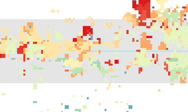 | The image represents the approximate course of the river, a 1 km riparian buffer and the areas with year of loss (see colour scheme) inside and outside the riparian zone. The demonstrated section of the Balombo River is the Canjala - Coastal section. See layer "1km_buffer_balombo_Benguela" See layer "1km_Buffer_Balombo_Benguela" |
Balombo plant water balance 3 locationsCoastal, Canjala and Balombo Municipality basin sections (see Map) | |||
| Precipitation (Graph) | Evapotranspiration (Graph) | Balanço hídrico (Graph) | MSI-EVI (Graph) |
| Balombo Coastal | Balombo Coastal | Balombo Coastal | Balombo Coastal |
| Balombo Municipal | Balombo Municipal | Balombo Municipal | Balombo Municipal |
| Canjala (irrigation) | Canjala (irrigation) | Canjala (irrigation) | Canjala (irrigation) |
Análise da rega atual – Bacia do Balombo (Canjala) | |
| principal área de irrigação por gravidade | Canjala é a principal área de irrigação por gravidade na Bacia do Balombo |
| Noutras localizações | A irrigação ribeirinha em terras baixas através de inundação, contribuição de água subterrânea ou abastecimento por bomba, encontra-se ao longo da costa e no curso superior da bacia. |
| A irrigação por bombagem ou a inundação natural | A irrigação por bombagem ou a inundação natural são reflectidas ao longo do Balombo e dos seus afluentes pela camada no mapa denominada “cultura irrigada” |
| Atualmente, a área irrigada estimada é de 1626 ha. | Atualmente, a área irrigada estimada é de 1,626 ha. Esta primeira avaliação tornar-se-á mais precisa durante o tempo de vida do monitor de recursos hídricos “Maji Yetu” |
| Camada de SIG | função |
| satélite (google) | = verificação de alta resolução, campos individuais e uso do solo |
| mapa de classificação do uso do solo (ESA world cover 2020) | 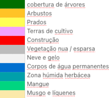 |
| Bacia do Balombo Topo | = diferenciação entre vales relacionados com cursos de água (irrigação por gravidade, zonas húmidas), irrigação por bomba, florestas elevadas ou outros pontos de elevada evapotranspiração, como clareiras |
| vala informal de rega | = indicadores da irrigação atual por gravidade (Setembro de 2023) |
| Canjala Vegetação húmida no final da estação seca (cultura potencialmente irrigada) | = indicador de irrigação possível em tempo real (Setembro Outobro de 2023) |
| curvas de nível de 100 metros | = acentuar informação topográfica Bacia do Balombo |
| Primeira seleção de vegetação úmida incluindo rega (Setembro de 2023) – Bacia do Balombo (píxeis de 275m) | |
 English (UK)
  Português